YAN, Liu (Liu Dezhi). [Ye Zipei].
Complete Map of the World with All Nations.
China: Wanguo Dadi Quantu, 1851 [Xianfeng period].
$30,000.00
In Stock
Item Number: RRB-131424
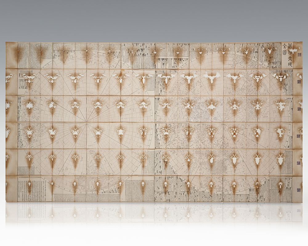
Exceptionally rare second edition of Ye Zipei’s complete map of the world, one of only two known copies produced by terrestrial globe expert Liu Yan
Exceptionally rare second edition of Ye Zipei’s complete map of the world, one of only two known copies produced by terrestrial globe expert Liu Yan. The terrestrial map is comprised of six accordion-style albums bound in handmade paper with white titular labels lettered in hand to each front panel. A woodblock print in red and black ink, the map features two hemispheres defined by straight meridian and circular parallel lines and a ground of red grids. The left hemisphere centers on the south pole, while the right one on the north pole; both are bordered by the equator, adopting the modern mapping techniques of conic equidistant projection and geographic coordinates. The map includes rivers, mountains, and geometrical shapes representing administrative units, annotated with place names in Chinese. Texts on the four sides include information of countries and places. An inscription from Ye Zipei’s original version of the map is preserved and printed at the upper left corner, including texts by Ye Zipei himself, his brother Ye Yunshi, collector Tan Jing and Yu Hao. The map contains two inscriptions by Liu Yan in 1851, one next to Ye Zipei’s inscription and the other at the lower left corner. Liu Yan, the producer of this map, was an expert of terrestrial globe making and a student of Li Zhaoluo (1769-1841) and based the present map on Ye Zipei's complete map of the world who, according to Liu Yan’s inscription at the top of the map, based his work on the famous world map Kunyu Quantu [Complete Map of the World] produced by Ferdinand Verbiest (1623-1688), and Huangchao Yitong Yudi Quantu [Complete Map of the Unified Empire] by Li Zhaoluo. The map was published three times: the first edition by Ye Zipei in 1845; the second edition revised and released by Liu Yan in the third month of 1851, with only two known extant copies, being the present map and the copy in the collection of Shijiazhuang Museum, Hebei Province (this copy is divided differently, into eight vertical strips); the third edition was also published by Liu Yan, in the autumn of 1851, renamed Dadi Quanqiu Yilan zhi Tu (Map with an Overview of the Whole Global World), a copy of which can be found in the collection of the National Palace Museum, Taipei. Exceptionally rare. Each of the six portions measures approximately 4 inches by 8 1/2 inches folded for an overall size of 50 1nches by 1000 inches.
Chinese cartography began in the 5th century BC during the Warring States period when cartographers started to make maps of the Earth's surface. Its scope extended beyond China's borders with the expansion of the Chinese Empire under the Han dynasty. By the 11th century during the Song dynasty highly-accurate maps drawn on grids were produced. During the 15th century, the Ming dynasty admiral Zheng He went on a series of voyages to the South China Sea, Indian Ocean, and beyond and maps for areas outside of China were produced, although world maps covering territories known to the Chinese outside of China existed as early as the Tang dynasty.
Complete Map of the World with All Nations.
$30,000.00
In Stock